
The U.S. Geological Survey (USGS) has released a new report detailing changes of groundwater levels in the Ogallala, or High Plains, Aquifer. The report presents water-level change data in the aquifer for two separate periods: from 1950 (which was prior to significant groundwater irrigation development) to 2015, and from 2013 to 2015.
“Change in storage for the 2013 to 2015 comparison period was a decline of 10.7 million acre-feet, which is about 30 percent of the change in recoverable water in storage calculated for the 2011 to 2013 comparison period,” said Virginia McGuire, USGS scientist and lead author of the study. “The smaller decline for the 2013 to 2015 comparison period is likely related to reduced groundwater pumping.”
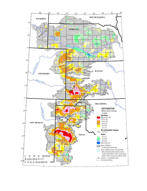
In 2015, total recoverable water in storage in the aquifer was about 2.91 billion acre-feet, which is an overall decline of about 273.2 million acre-feet, or 9 percent, since predevelopment. Average area-weighted water-level change in the aquifer was a decline of 15.8 feet from predevelopment to 2015 and a decline of 0.6 feet from 2013 to 2015.
The USGS study used water-level measurements from 3,164 wells for the predevelopment to 2015 study period and 7,524 wells for the 2013 to 2015 study period.
The Ogallala underlies about 112 million acres, or 175,000 square miles, in parts of eight states: Colorado, Kansas, Nebraska, New Mexico, Oklahoma, South Dakota, Texas and Wyoming. At the request of the U.S. Congress and in cooperation with numerous state, local and federal entities, USGS has published reports on water-level changes in the aquifer since 1988 in response to substantial water-level declines in it.
“This multi-state, groundwater-level monitoring study tracks water-level changes in wells screened in the High Plains aquifer and located in all eight states that overlie the aquifer. The study has provided data critical to evaluating different options for groundwater management,” McGuire said. “This level of coordinated groundwater-level monitoring is unique among major, multi-state regional aquifers in the country.”
Continue reading more from USGS, or read the full report.