By Eva Vigh
The more Texans know about their water and other natural resources, the more likely they are to participate in conserving and protecting these resources. Additionally, professionals must understand emerging management tools to address critical natural resource issues.
The Natural Resources Training Program of the Texas Water Resources Institute (TWRI) and Texas A&M Natural Resources Institute (NRI) serves interested landowners and citizens as well as water and natural resource professionals and offers intensive, educational courses across the state.
The two main goals of the program are to provide landowners with appropriate practices to address natural resource issues and to offer training for professionals on natural resource management tools, innovative technologies, geographic information systems (GIS) and computer models.
Watershed Short Course
TWRI initiated its first training course — the Texas Watershed Planning Short Course — in 2008 in an effort to teach the necessary strategies for developing a watershed protection plan.
Implementation of such strategies has a significant impact on water resources in terms of quality and supply, said Dr. Kevin Wagner, TWRI associate director.
“Education is imperative to achieving long-term improvements in both water conservation and water quality,” he said. “This is a well-established fact that has been demonstrated in study after study.”
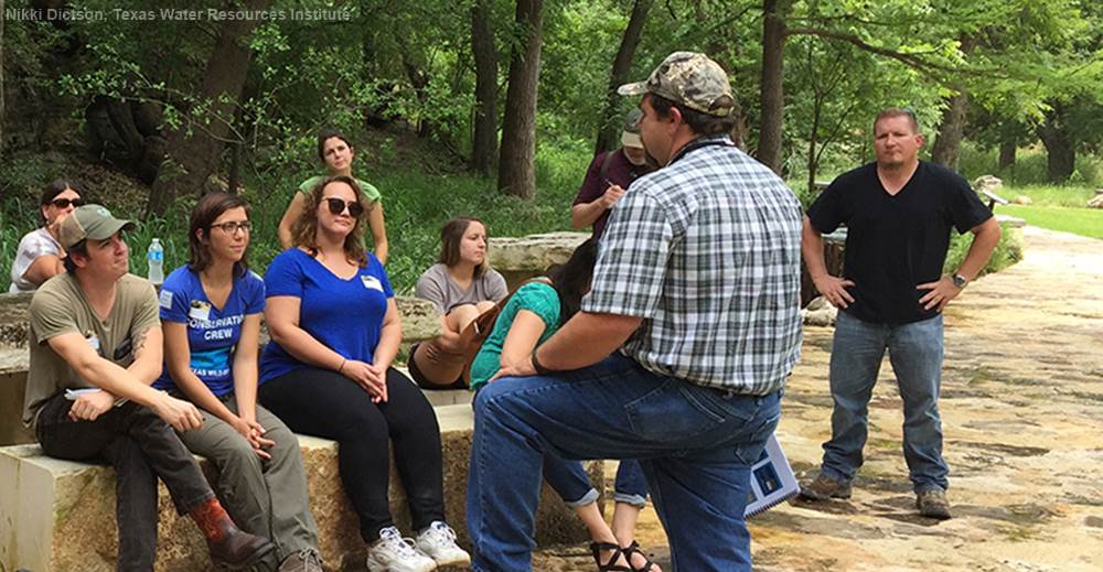
The short course was developed as a weeklong training in response to the U.S. Environmental Protection Agency’s nine-element watershed planning guidelines to help watershed coordinators practice sustainable procedures and implementation strategies in managing water quality. Watershed restoration and protection topics such as data collection and analysis, stakeholder coordination and tools for plan development are covered in this course.
Education is imperative to achieving long-term improvements in both water conservation and water quality. This is a well-established fact that has been demonstrated in study after study.
Watershed Coordinators Roundtable
According to Nikki Dictson, Texas A&M AgriLife Extension Service program specialist for TWRI and coordinator of the training program, watershed coordinators from around the state also meet at the biannual Texas Watershed Coordinator Roundtable to discuss program updates, funding and any concerns or innovations to improve watershed planning and implementation efforts.
As a result of the roundtable meetings, the Fundamentals of Developing a Water Quality Monitoring Plan and Introduction to Modeling trainings were introduced to provide further support for professionals in implementing monitoring strategies for characterizing and evaluating watersheds. Other trainings include Getting in Step, Stakeholder Facilitation and Implementation workshops.
Meeting training needs
TWRI continues to create new trainings to meet the needs of interested stakeholders as well as water and natural resource professionals, Dictson said.
In 2012 TWRI began the Texas Riparian and Stream Ecosystem Program. Dictson said the program’s goal is to promote healthy riparian zones by educating stakeholders on riparian principles, watershed processes, hydrology, erosion/deposition principles and vegetation and to provide the tools to prevent degradation and improve water quality.
Landowners, agency staff, city officials and the public are encouraged to attend the riparian workshops held in different watersheds around the state. At the workshops, they learn about the important benefits of healthy riparian areas, which act as buffers to stabilize banks, prevent erosion and filter out sediments and pollutants.
Dictson said the riparian program has been very successful since its start, with 1,030 attendees impacting a combined acreage of more than 187,000 acres. More than 99 percent of post-workshop evaluations showed that participants were mostly or completely satisfied with the program and course materials and all would recommend this course to others. Additionally, 94 percent said they would adopt management practices discussed in the course to improve riparian management and water quality.
“I loved the workshop and learned so very much about this fascinating and integral part of our ecosystems,” wrote an attendee of the riparian workshop in Hamilton. “The tragic news reports of Wimberley and the Blanco River are horrific,” she said, referring to the Memorial Day flash floods. “Your workshop’s messages are more important now than ever, as the streams and rivers heal...as well as the people who live by and love them.”
Dictson said this attendee was very instrumental in bringing the riparian workshop to Georgetown in September, where more than 100 attendees gathered to learn about the riparian areas in the San Gabriel River Watershed.
“We’ve done more than 25 riparian landowner workshops across the state,” Dictson said. “These are geared toward priority watersheds addressing water quality issues.”
Additional trainings offered through the riparian program include the Introduction to Proper Functioning Conditioning (PFC) Training — an overview of the riparian assessment method used to rate functional processes of riparian zones. Multiple conferences co-sponsored by the program included the 2015 Urban Riparian Symposium in Austin, which presented timely information regarding a variety of stream and riparian issues to participating professionals through workshops, keynote speakers and presentations.
The Natural Resources Training Program continues to engage landowners, water coordinators and professionals, expanding the different trainings and workshops throughout Texas.
If professionals express a need for a previously held course, Dictson said she tries to accommodate that. The program recently offered the Water Rights Analysis Package (WRAP) Fundamentals Short Course in response to such requests.
Led by Dr. Richard Hoffpauir of Hoffpauir Consulting in College Station, the WRAP course offered the opportunity to obtain hands-on experience with the modeling system and gain an understanding of basic water rights analyses. The Texas Commission on Environmental Quality’s Water Availability Modeling system uses WRAP along with input datasets for all the river basins of Texas.
ArcGIS training
Partnering with TWRI, IRNR offers an Introduction to ArcGIS 10 course. Professionals in nearly every field can take advantage of the course, which provides participants with a solid foundation of understanding ArcGIS software and basic GIS tasks, said Amy Snelgrove, a program coordinator for TWRI and NRI.
“GIS is a tool that allows you to study relationships between various geographic features, based on both their physical attributes as well as their location on the surface of earth,” Snelgrove said. “Through GIS analysis, you can see spatial patterns in data, giving a better understanding of how the location of features influences traits or locations of other features.”
Through GIS analysis, you can see spatial patterns in data, giving a better understanding of how the location of features influences traits or locations of other features.
Users can not only analyze the location of features, but look at characteristics of those features as well. GIS analysis can be particularly useful for watershed analysis in determining the flow of water, municipal water usage and possible sources of contamination, Snelgrove said.
“Our training courses and workshops have evolved and improved over the years, continually serving Texans and meeting education needs,” Wagner said. “We will continue to provide the best in water and natural resources training.”
