
In 2015, agencies and officials counted the number of shared groundwater aquifers flowing beneath the U.S.-Mexico border to be 11. But after nearly a decade of geological and hydrological research, Rosario Sanchez, Ph.D., revealed a far more complicated picture.
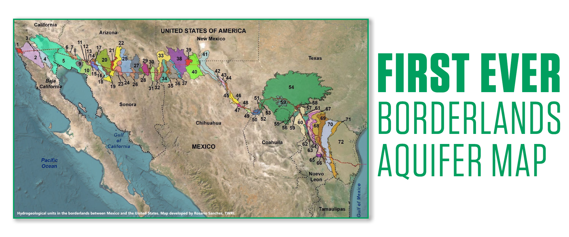
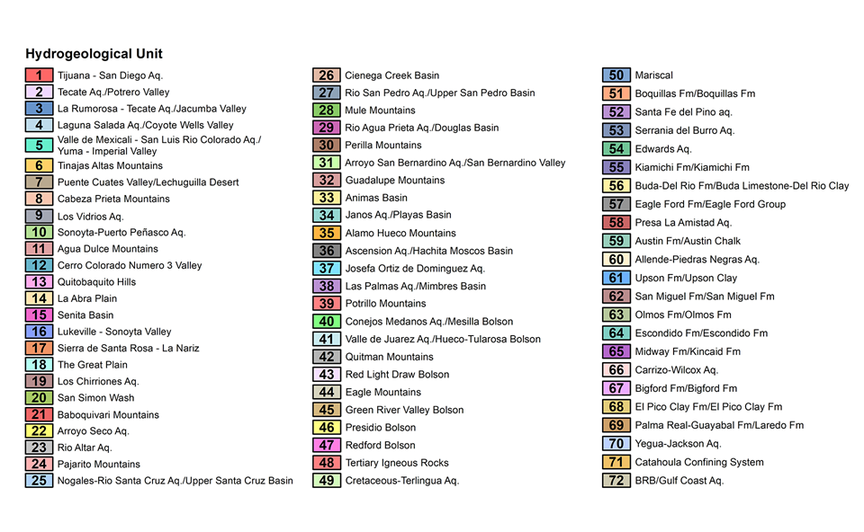
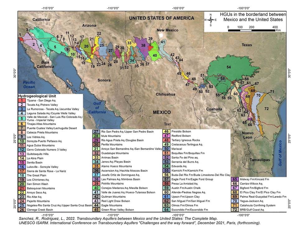
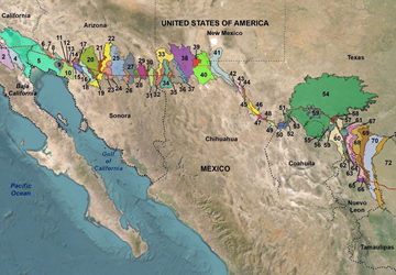
When Sanchez published the first-ever complete map of the U.S.-Mexico transboundary aquifers in January 2023, the map showed that there are actually 72 shared aquifers in the region.
This includes five aquifers between Baja California and the state of California; 26 between Sonora and Arizona; and 33 between Texas and the Mexican states of Chihuahua, Coahuila, Nuevo León and Tamaulipas. Sanchez said 45% of the aquifers were found in “good to moderate” condition.
Sanchez is a senior research scientist for the Texas Water Resources Institute (TWRI). She is also the director of the Permanent Forum of Binational Waters and leads the Transboundary Aquifer Assessment Act program for Texas. Laura Rodriguez, a Ph.D. candidate in Texas A&M University's Water Management and Hydrological Sciences graduate program, co-authored the research and worked as its resident geologist.
Filling in the blanks
Prior to Sanchez’s publication, some groundwater maps and databases run by state and federal agencies had blank regions around the border — incomplete records of groundwater supplies integral to the region’s communities and economy, she said.
We don’t have the luxury to keep ignoring the shared component of these resources. We have to address this sooner or later, because the less we know, the more vulnerable we are.
While the map has helped fill in the blanks, there is currently no formal legal or policy framework at a binational level to address transboundary groundwater management in the border region. These aquifers underlie more than 121,500 square miles of land that is experiencing population growth, drought and climate change impacts. Sanchez said this could put both nations in precarious positions.
“We don’t have the luxury to keep ignoring the shared component of these resources,” she said. “We have to address this sooner or later, because the less we know, the more vulnerable we are.”
To define the aquifers, Sanchez’s team first studied the regions’ geological formations, spanning both sides of the border, then the type of formations and their porosity. “Every point in that map was a decision we had to make, based on the physical condition and scientific data,” she said.
Estimate reading time: 4 minutes
TWRI’s Rosario Sanchez reflects on leading the development of the first complete U.S.-Mexico borderlands aquifer map and why it matters
More Information
- Permanent Forum of Binational Waters
- Transboundary Water Portal, TWRI
- Texas A&M AgriLife scientist publishes complete U.S.-Mexico borderlands aquifer map, TWRI
Want to get txH20 delivered right to your inbox? Click to subscribe.
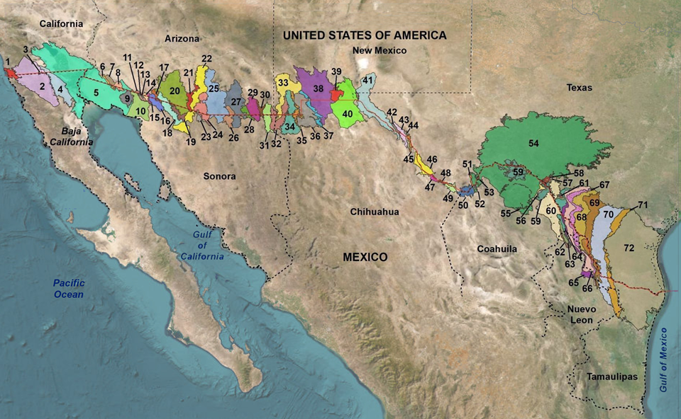
Hydrogeological units in the borderlands between Mexico and the United States. Map developed by Rosario Sanchez, TWRI.
“Our analytical method used geology, topography, lithography, geomorphology and hydrology to identify hydrogeological units (HGUs) and those HGUs that have good aquifer potential at the transboundary level,” Sanchez said.
Since the map’s publication, they have also been working to assess the aquifers and evaluate priority areas based on the pumping patterns at the transboundary level, and their level of transboundariness, a concept she coined in 2020. Transboundariness is defined as the strategic value that an aquifer acquires by being located at the border, Sanchez said. Economic, social and political conditions also play a role in its level of transboundariness.
This particular science, that touches two different jurisdictions, political systems and cultures, requires much more than just science to be useful, applicable and recognized. We didn’t just do this for the sake of science.
Additionally, she continues to quantify and communicate all the unknowns in the region.
“We don’t know how much water has been withdrawn,” Sanchez said. “We don’t know the impact of that on the other side of the border or vice versa. We don’t know the quality of that water. We don’t know who has been drilling wells or for what use. We don’t know what has possibly been pumped into these aquifers. And, we don’t know how much water we have left.”
Response to the revolutionary
The map was well received by both countries, Sanchez said, and throughout the 10-year process, the researchers made sure to constantly consider the perspectives of both sides.
“This particular science, that touches two different jurisdictions, political systems and cultures, requires much more than just science to be useful, applicable and recognized,” Sanchez said. “We didn’t just do this for the sake of science.”
Few funding opportunities for continued research existed previously, but the map’s impact, the international network of transboundary water researchers and the growing need for efficient groundwater use have all helped the area get more attention from decision-makers, she said. The U.S. Geological Survey recently began pursuing more funding for shared groundwater resources research.
Sanchez’s publication is already used by the International Groundwater Resources Assessment Centre (IGRAC), which maps and monitors transboundary aquifers globally. It is also used by the Binational Groundwater Task Force, and both organizations have helped with the map’s visualization.
To make progress, leaders must figure out water resources’ role in the binational agenda and the implications for future regional water security, she said.
“And, we get to help, we get to participate, we get to collaborate, we get to be part of the decision-making process,” Sanchez said. “We are walking with the leaders, which is the most important part of our research. That is my passion.”
Explore this Issue


Authors

Madalyn Richards was a communications intern at the Texas Water Resources Institute, creating social media content and writing for TWRI’s various publications.